
Bulletin 10: Oil spill trajectory model forecasts that spill will flow through the Verde Island Passage for the rest of the week
Featured image: Bulletin 10: Oil spill trajectory model forecasts that spill will flow through the Verde Island Passage for the rest of the week
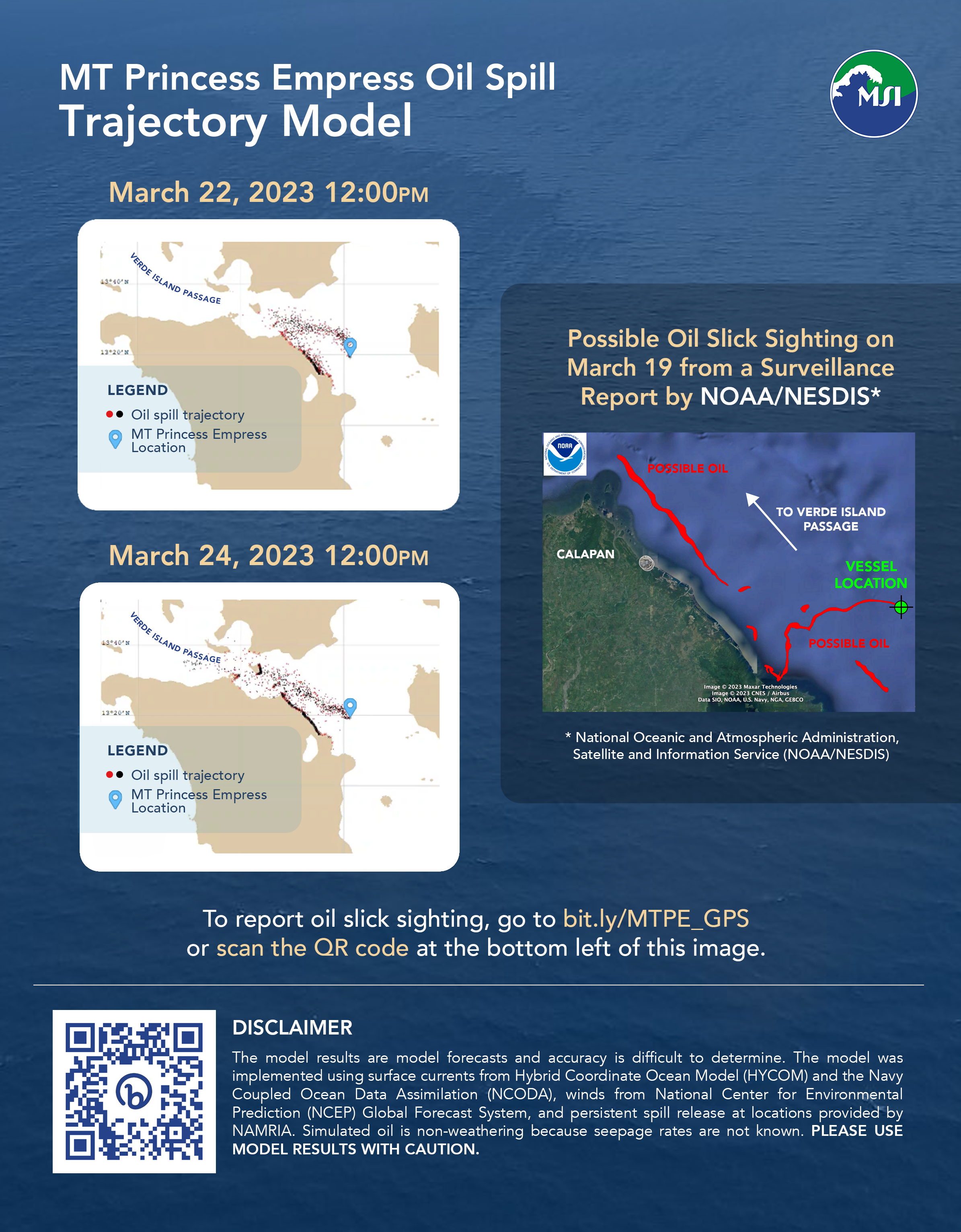
The oil spill threatens the global center of marine biodiversity located in the Verde Island Passage (VIP). The latest satellite image on March 19 shows that the oil is still leaking out of the sunken vessel, and the visible slick is extending northwest towards the VIP. Oil spill trajectories for March 17-26 forecasts that the spill will flow through the VIP for the rest of the week. Weaker winds and calmer seas are ideal conditions to collect the oil near the source using booms and skimmers and prevent the oil from spreading further.
Westward currents along northern Mindoro towards the Verde Island Passage are continuing. Winds are weaker, more variable, and shifting to easterlies (or winds coming from the east) blowing to the west through the VIP this week. Due to weakening winds, oil slicks with larger areas are able to form. These slicks may be brought by the wind to the VIP.
The VIP is the body of water between Batangas and Mindoro and it has the highest concentration of coastal fishes, corals, crustaceans, molluscs, seagrasses, and mangroves. The VIP is also home to endangered and threatened species including the critically endangered hawksbill turtle, whale sharks, manta rays, dugongs, humphead wrasses, giant groupers, and giant clams. Damage from the oil spill may affect biodiversity (including endemic species only found in the Philippines as well as species yet to be discovered), tourism revenues, and food security in the area.
We need continuous monitoring along the coasts for the presence of oil to improve the models. The public is encouraged to contribute geotagged images using a GPS camera app so that coordinates can be used as starting locations for the oil in new model forecasts. Please submit these geotagged images through this form.
Disclaimer: The model results are model forecasts and accuracy is difficult to determine. The model was implemented using surface currents from Hybrid Coordinate Ocean Model (HYCOM) and the Navy Coupled Ocean Data Assimilation (NCODA), winds from National Center for Environmental Prediction (NCEP) Global Forecast System, and persistent spill release at locations provided by NAMRIA. Simulated oil is non-weathering because seepage rates are not known. Please use model results with caution.